
Surviving wildfires
Definition:
A wildfire, forest fire, or a bushfire is an unplanned and uncontrolled fire in an area of combustible vegetation. Depending on the type of vegetation present, a wildfire may be more specifically identified as a bushfire, desert fire, grass fire, hill fire, peat fire, prairie fire, vegetation fire, or veld fire.
Causes of wildfires:
Neary 85% of wildfires are caused by people. That’s a consistent statistic from around the world So how do we cause such damage? Typically, it’s a result of fires being left unattended (such as barbecues or camp fires), discarded cigarettes, the burning of debris, broken glass, equipment use / malfunctions and intentional acts of arson.
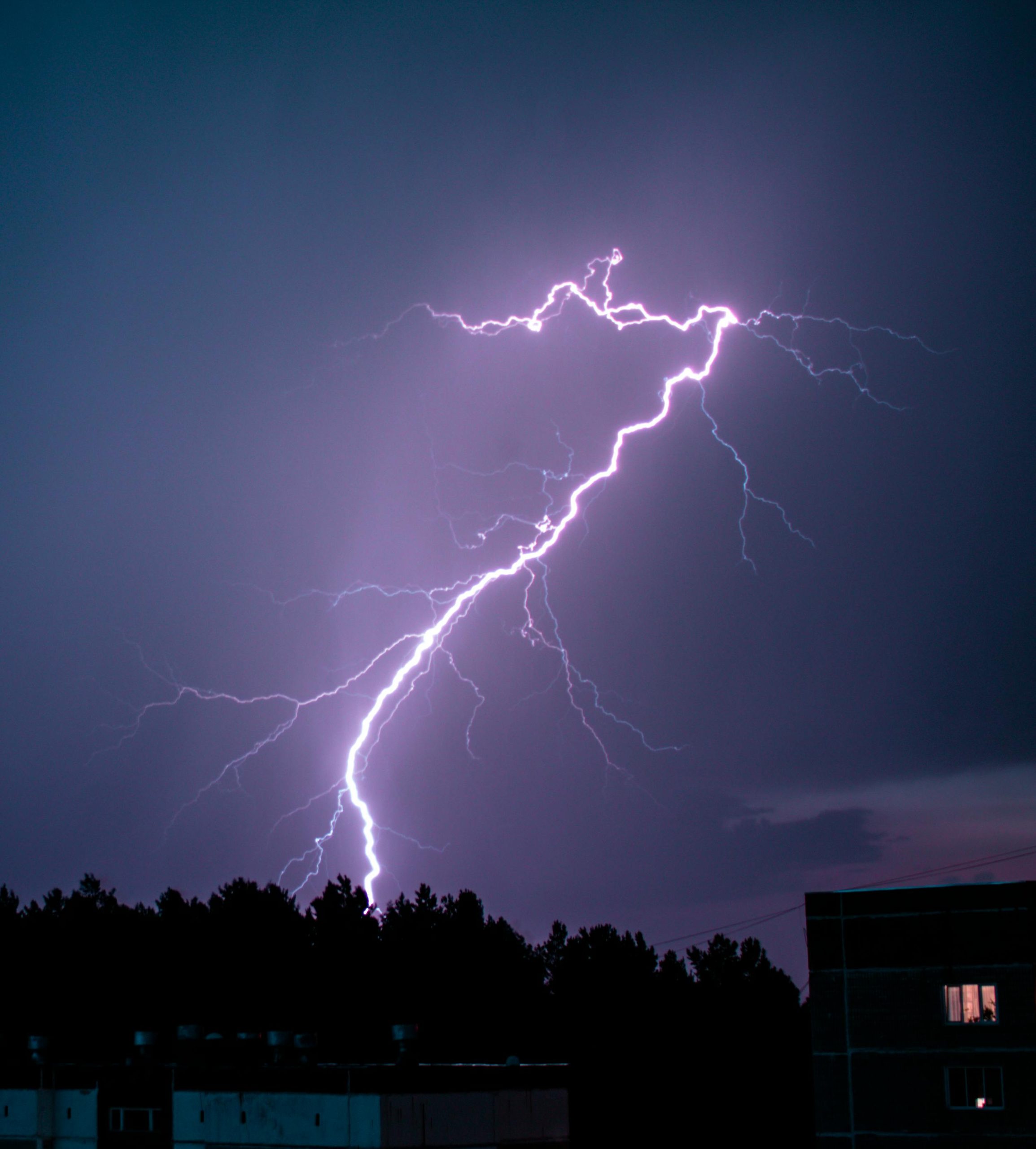
Lightning is another contributor but not nearly as much as human beings, and not all lightning strikes cause fires. There are 2 types of lightning strike – hot strikes and cold strikes. The difference between hot and cold lightning strikes is the duration of the electrical flow during the strike. A hot lightning strike involves a continuing current whilst cold strikes involve return strokes dissipating electrical current back up into the atmosphere. Both are still hot, but the hot strike hangs around longer with more current passing that heats up objects to their ignition temperature.

Combat indicators:
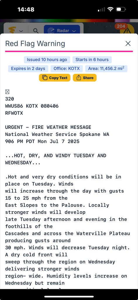
The weather is not going to help us out on this one. The risk of wildfires greatly increases when we have spells of hot / dry weather. We saw this in London in July, 2022 where a major incident was declared because the brigade had attended over 200 fires within 24 hours which was their busiest day since World War II. The environmental conditions leading into these fires (40 degrees C / 17% humidity / winds out of the South @ 17mph) meant people were urged to refrain from having barbecues and discarding cigarettes near dry vegetation. The Wennington fire pictured was caused by a compost heap that spontaneously combusted, then spread to a garden fence and onto the houses. There was a fire station in the village, but they were already committed to fires in other areas.
The point we are trying to make here is that these spells of weather dry out vegetation which is then basically kindling. The smallest of ignition source such as a broken glass (which acts like a magnifying glass creating a hot spot), a spark from machinery or during hot works, an ember from a barbecue / chimenea, or a discarded cigarette can end up in chaos.
The wind is also worth a talking point as its going to drastically impact fire spread and growth. Winds will push flames onto surrounding vegetation & buildings which results in rapid fire spread. We will talk about wind a lot throughout this article.
Tracking wildfires:
So, we have switched on the news and we can see warnings of warm, dry weather. Thankfully in 2025, with technology ever evolving we are lucky to have so much information at our fingertips.
There are some great websites to reference such as below. There are sources like this for all regions so if yours is not listed – a quick google search will find what you’re looking for:
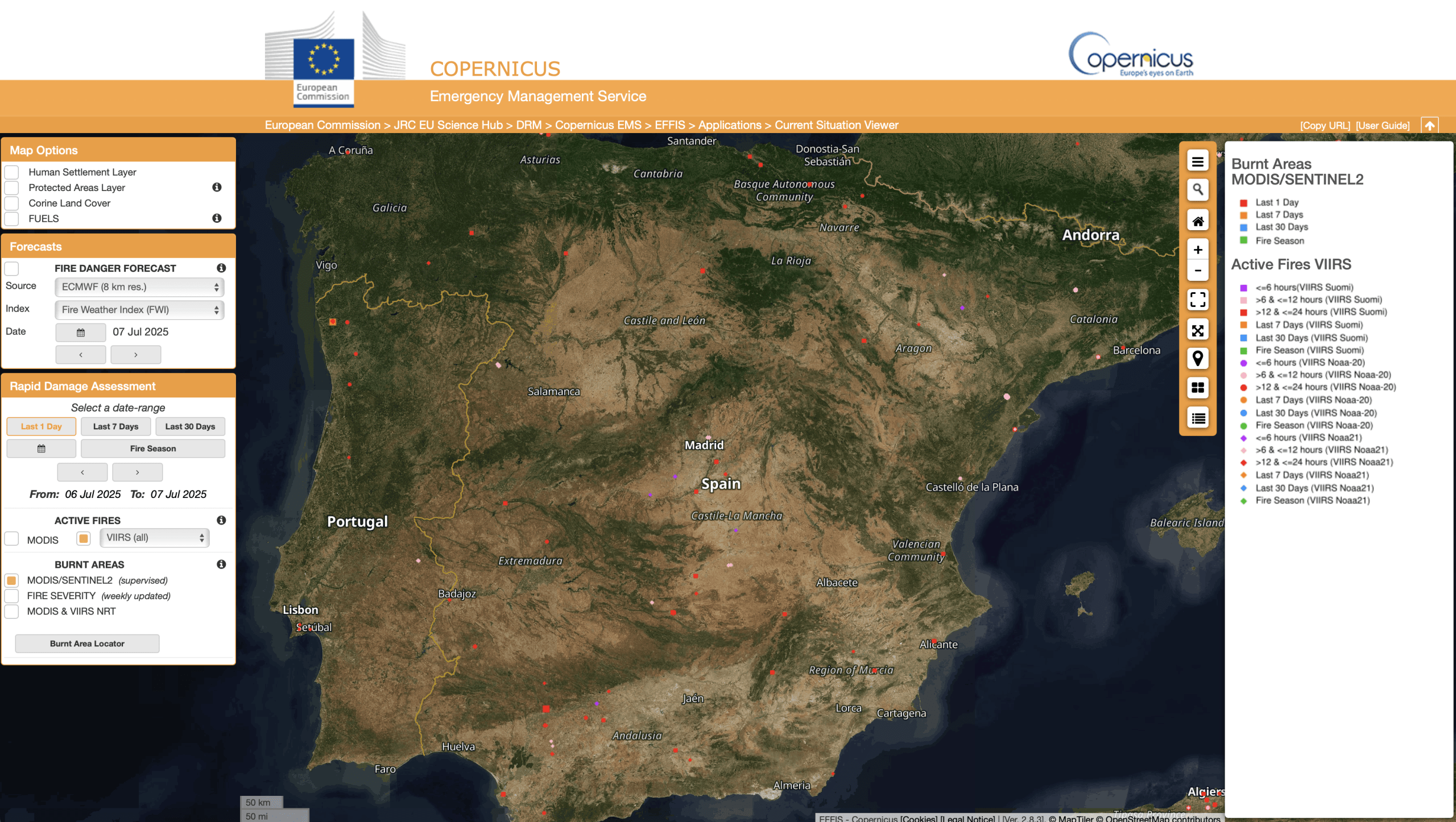
Europe:
https://forest-fire.emergency.copernicus.eu/apps/effis_current_situation/
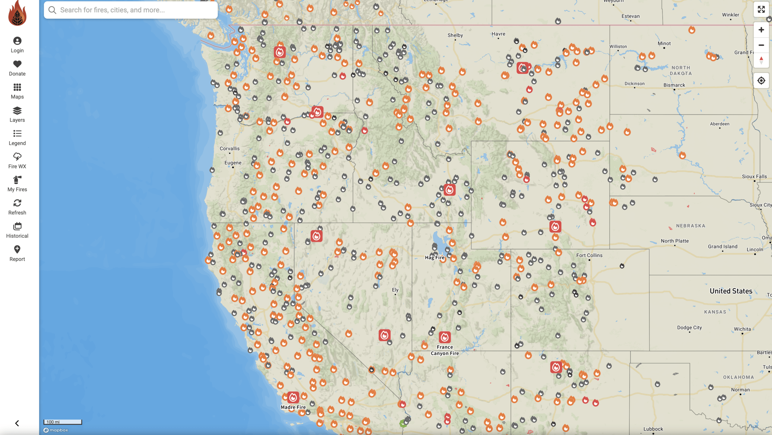
United States:
https://fireweatheravalanche.org
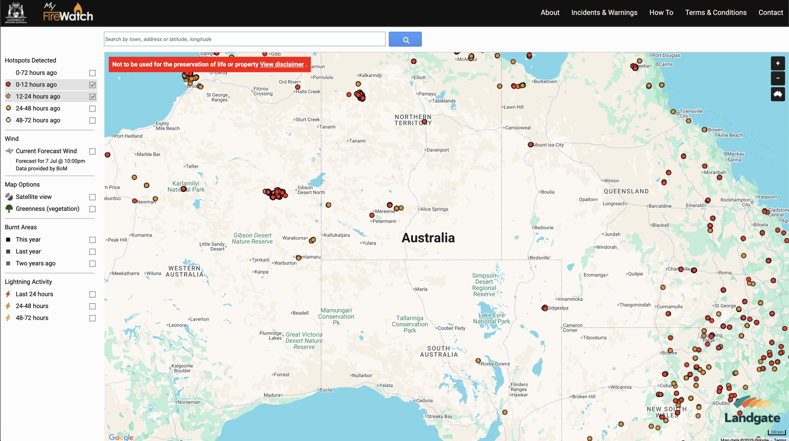
Australia:
https://myfirewatch.landgate.wa.gov.au/map.html
As you can see from the images, there is a wealth of information regarding the wildfires. We can see how old the data is, the areas impacted and due to be impacted by the fires themselves. The other thing we would look at is local weather forecasts and review the following days outlooks. Look at temperatures, humidity and winds. Are the temperatures favourable for vegetation to dry out? (if you live in a warm climate, this is probably already the case), are the dewpoints low? What is the relative humidity? What is the wind speed and direction?
Once we have informed ourselves of what the weather is doing, we can then get a good idea of how the fire is going to proceed if it’s not extinguished of course.
Wait it out, or get out?
This is all very subjective to location but in any case, local emergency services will hopefully be on hand to advise on the best course of action. In wildfire prone environments they issue warnings early. The considerations are different from region to region, Greece, Spain, France to the outback of Australia or in the woodlands of California. If we were remote with little resources – we would rather be safe than sorry. As the old saying goes – if in doubt, get out.

Preparing to evacuate:
This is all very subjective to location but in any case, local emergency services will hopefully be on hand to advise on the best course of action. In wildfire prone environments they issue warnings early. The considerations are different from region to region, Greece, Spain, France to the outback of Australia or in the woodlands of California. If we were remote with little resources – we would rather be safe than sorry. As the old saying goes – if in doubt, get out.

Zero warning?
In this case – it’s about getting out as soon as you can, making sure you grab comms, the goggles, respiratory protection and some water. Chances are – if a wildfire has snuck up on you, then the probability is that it’s started nearby and hopefully there are still options to escape before the fire has developed to the point that you’re surrounded. It’s highly unlikely that a well developed wildfire is in play with no prior warnings being broadcast. The other thing about them, they’re not very inconspicuous… you can literally see them coming miles away.
Being prepared…
As with anything, being prepared is key. If you live in a wildfire prone environment, then what’s written in this article hopefully won’t be new to you. The weather gives us our combat indicators – sustained warm, dry weather. If we live in a wildfire prone environment – have evac bags packed, fuel in the car and your devices charged so if it does happen, we can just jump in our vehicles and hit the road (don’t forget the dogs).
A force of nature, reading the beast!
In this section we are going to talk about reading the environment and gain an understanding of how we can evade a wildfire. We have discussed above about what preparation we can do before a wildfire but now we need to take further steps to read the scenario in front of us.
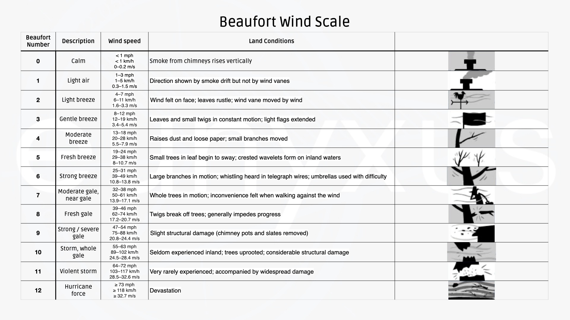
The wind & the Beaufort Scale:
There is a simple guide that we can use to assess wind speeds by eye. The trusty Beaufort Scale was the work of a British Admiral called Francis Beaufort. He developed the scale in 1805 to help sailors estimate wind speeds through visual observations. So, it’s not an exact science, it’s not perfect (comparing it to an anemometer) but it gives us a good idea of how strong the wind is. As we can see from the table, it gives us quick visual references of wind.
It’s worth noting at this point that forecast winds and winds local to wildfires can often be drastically different due to the heat causing turbulence in the upper & lower levels of the atmosphere.
The atmosphere and the effects on smoke:
Understanding what smoke patterns we are likely going to see in the atmosphere can give us an idea of what is potentially happening at ground level.
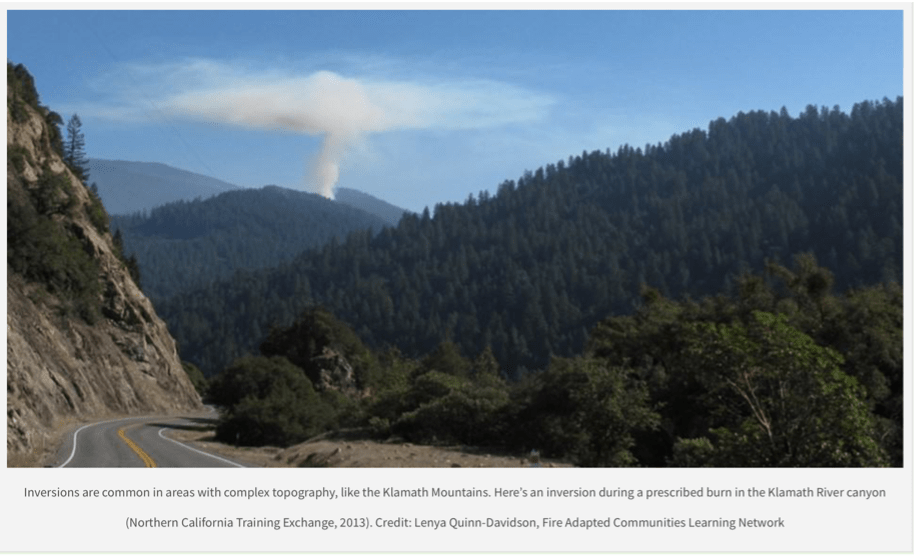
Stable atmospheric conditions:
If we see a smoke column that represents a Lenticular cloud, this means that the smoke is trapped under a temperature inversion which is found in a stable atmosphere. As we can see from the image to the left, the cloud spreads out in all directions at a certain height, it has limited vertical motion due to the temperature inversion.
This means that there is likely going to be higher smoke exposure levels, reduced visibility and reduced fire behaviour.
There is a risk of what is known as boil through – which is where the smoke overcomes (through convection) the stable layer in the atmosphere which can lead to wind shifts, increasing flames, spread & spotting. It will look like an overshooting top in a cumulous cloud during a severe thunderstorm.
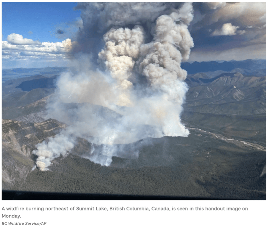
Unstable atmospheric conditions:
In unstable atmospheres, smoke rises high and disperses. This can be associated with gusty winds but will maintain good visibility In an unstable atmosphere we are likely to see active / rapid fire spread with intense burning.
The image to the right shows an unstable atmosphere allowing the smoke to penetrate high into the stratosphere. The upper winds then push the smoke layer for many miles.
It is also common to see the development of pyrocumulonimbus clouds which will result in lightning activity downwind of the wildfires, potentially causing new wildfires many miles away from the source.
There’s a lot that the environment will tell us which in turn helps us with our decision making and it just goes to show, even though the wildfire maybe tens or hundreds of miles away from us – it can still affect us and this is why we need to be prepared and have a clear action plan.
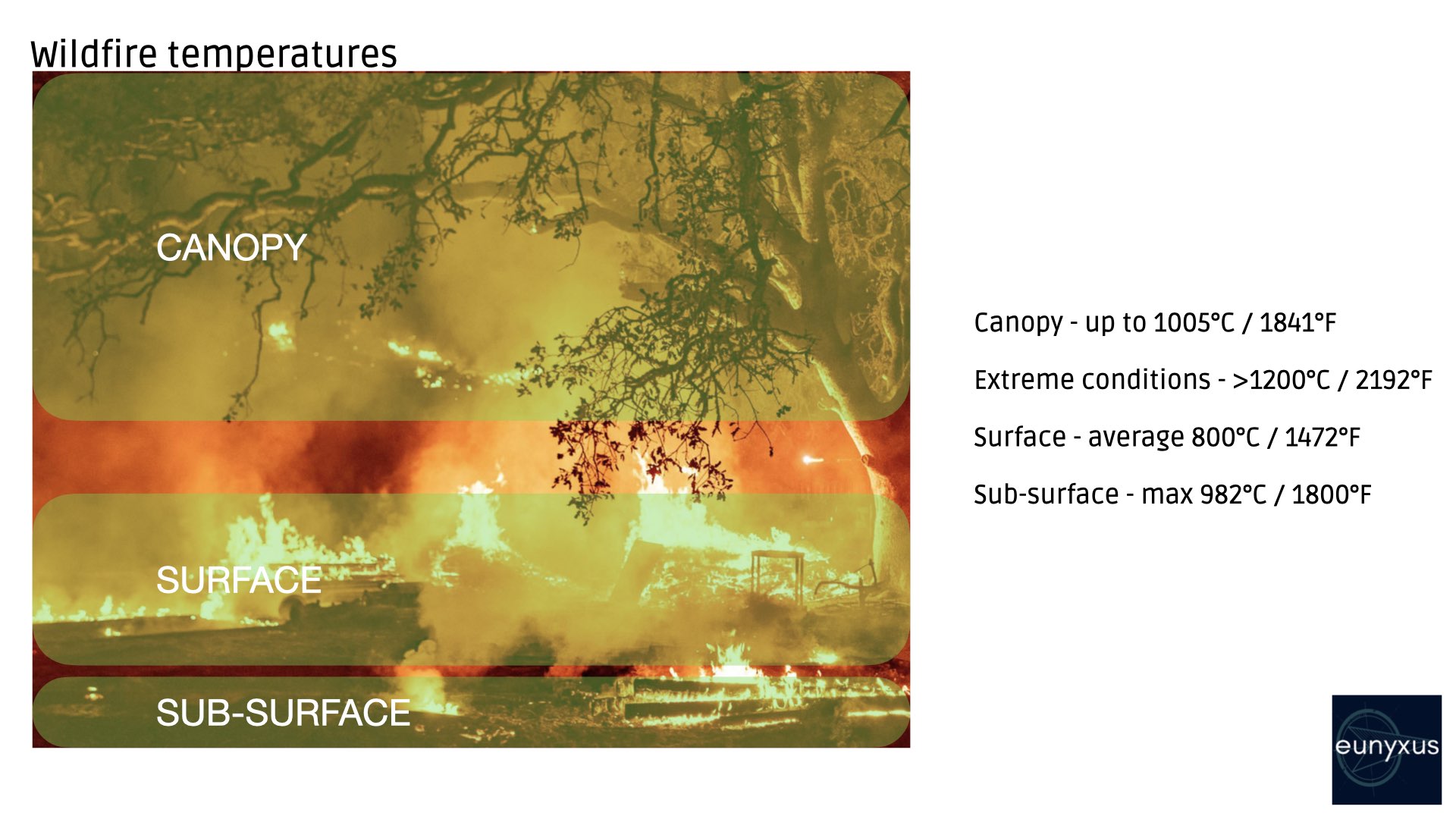
The temperature gauge:
The reason why preparedness is key, is because surviving a wildfire is difficult. You can see from the table to the left that the temperatures are extreme. Wood reaches its firepoint (the point at which a fuel is hot enough to give off enough vapour to sustain a flame when an ignition source is applied) between 250 – 300 °C / 482 – 572°F.
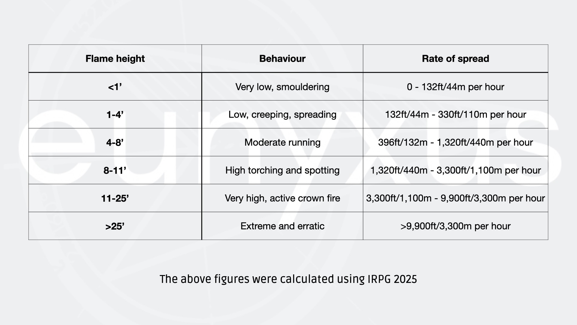
Rate of spread:
Wildfire can spread at an incredible rate. In extreme circumstances it can spread over 3km in an hour, there are a lot of contributing factors that can influence the rate such as topography. Fires moving uphill will spread a lot faster than heading downhill for example. We have already discussed winds and the atmosphere but that has a huge impact on spread rates. Lastly, we must consider the fuels available to the fire. Is it heavy, dense wood or is it grassland? The rate of spread is typically calculated by flame height. For example, a flame measuring a meter tall can travel between 44m – 110m in an hour. The adjacent table shows typical rates.
As we can see, the potential for fire spread is terrifying, however if we have adopted the approach of being prepared then our decisions are already made before the fire is even close to impacting us.
Means of escape:
Drawing this blog to a close, we’ve saved the most important topic till last. It’s all well and good diving into the science, behaviour and forecasting of wildfires but it means nothing if we don’t have a plan to escape it.
Considerations:
- Have multiple escape routes that lead in different directions.
- If on foot, escape routes should not be uphill
- Be familiar with escape route surface types (asphalt/sand/trails/rocks etc) and where the routes go. This should all be recce’d ahead of time.
- Consider how arduous the terrain is and your parties fitness levels, fatigue and temperature factors. This may discount certain escape routes for people moving on foot.
- Should be able to be used day or night.
- Evaluate escape time & rate of spread.
- Vehicles to be parked ready for escape.
If you are using vehicles to escape a wildfire, or if you are transiting through an area that is still being affected by fire consider using fire blankets to cover vehicle windows. Fire blankets (in the UK) are rated up to 900°C and may offer a good layer of protection from falling embers, burning branches etc. Also, if you are in an environment where you can see or smell smoke – its time for eye and respiratory protection. Always protect the eyes and the lungs as they would be 2 of the main ingress routes for airbourne chemicals and particles that can affect you. Always think about your health, it’s a number one priority. Smoke inhalation will cause immediate trauma to your airways and can cause many respiratory diseases such as lung cancer later in life.
There’s a lot to think about, it’s not something that we want to chance with luck. If we were in a wildfire prone location, we would have a plan prepared to know exactly what to do if it was to happen. Hopefully, it’s a plan that we spend a bit of time implementing that we never have to use.
Resources:
Collecting data to be able to stay safe in wildfires is essential, we have already highlighted a few in the article already. Here we have some additional resources for your perusal.
Disclaimer; we are not sponsored, nor do we have any partnerships with our recommended resources, but we do believe in promoting great products that are invaluable to our work.
Links:
European Wildfire map:
https://forest-fire.emergency.copernicus.eu/apps/effis_current_situation/
United States Wildfire Map:
https://fireweatheravalanche.org
Australian Wildfire Map:
https://myfirewatch.landgate.wa.gov.au/map.html
Accuweather
Topo Map generation


Weatherwise is our go to app for anything weather related. Live radar, weather warnings & watches. Check the website to see if it’s up and running in your region, we highly recommend everyone to have this. From their website they are working on adding more countries to their radar service and the best part – it’s FREE!
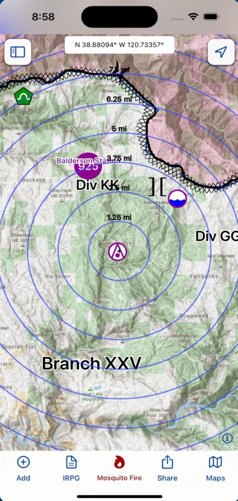
For people in the US, Topo Fire is unbeatable and if you’re working or living in a wildfire environment – it’s definitely one to have. Live updates, location sharing and planning features make it a fantastic tool. There is a subscription model attached to the services with a trial period if it’s something that you would like to try.
The 2025 NWCG Incident Response Pocket Guide is invaluable. It’s been created for front like firefighters tackling wildfires but there is also a lot of other useful information in there. Again, this is another free app, there is also the physical aide memoire style booklets available. Again, another must have from team eunyxus.
In closing:
If you have taken the time to read the article, thank you. We hope the information here helps you in one form or another.
If you require any further help, recommendations or have a query for us, please feel free to reach out using our contact page and a member of the team will contact you at the earliest opportunity.
Thank you.
eunyxus